My interest in the history of the suburb where I’ve lived now for over 35 years has slowly increased over that time. In researching and writing the posts in this blog, I’ve progressively covered varying aspects of life over the 140 years of European occupation of the land and a little of the time before. Below I’ve outlined some of that story and included links to some of the posts in my blog. You can also click the “posts” tab to browse the posts.
A Little of Highgate Hill’s History
For the most part, the land that today comprises Highgate Hill consisted of rocky hilly country covered with open woodland. Numerous small streams flowed down from the heights after rain either directly to the river on the southern side or north to swampy West End, South Brisbane and Woolloongabba (Kurilpa – Water, Water, Everywhere ).
The area was called Bennung-urrung after the frilly lizard or bearded dragon. They are still seen from time to time in the area.
It was a place of hunting where possums, squirrel gliders and wallabies were found. At the edge of Highgate Hill, along the ridge that extended from near Brisbane State High School to the Mater Hospital, was a major habitual camping ground. (South Brisbane War Memorial Park and the Disappearing Ridge) There was a bora ground near the corner of Baynes Street and Hampstead Road although most ceremonial locations were in the Woolloongabba area.
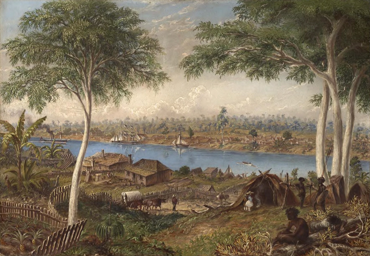
The view from Dorchester Street showing an Aboriginal Camp (Thomas Baines 1868, from a 1855 sketch. National Library of Australia.)
Surveyor John Galloway mapped Aboriginal pathways on his survey plan of November 1855. Many of today’s principal roads follow these pathways, as can been seen from the map below.

The Aboriginal pathways from Surveyor John Galloway’s 1855 survey plan, as they appear on a modern map. (openstreetmap annotated by P. Granville)
Joseph Backler’s 1867 painting of the view from Highgate Hill shows how these pathways slowly transformed into today’s roads.

An 1867 view of Brisbane by Joseph Backler, showing the typical vegetation on the hills of Highgate Hill. (National Library of Australia)
European settlement
After the arrival of Europeans, convicts were brought to Highgate Hill to fell timber, which was transported to town by boat. After Brisbane was opened to free settlement in 1842, land south of the town boundary, later Vulture Street ( Vulture Street – From Dotted Line to Bitumen ), was surveyed and divided into portions. These were typically of around 9 acres. They were progressively sold off at Government auctions through the 1850s and early 1860s, usually for around £2 to £4 an acre.

Crown Land Grants, Highgate Hill. (Qld State Archives)
Some blocks were held as investments, such as Stephens’ Paddock ( “Dorra Tor” – Plywood, Politics and Punters). In some cases, the owners established large homes on the tops of ridges. Early settlers included the Blakeney family ( The Blakeneys of Highgate Hill )who built two homes around 1862, neither of which have survived. Further down Dornoch Terrace, Captain O’Reilly built “Toonarbin” (Toonarbin )in the late 1860s, still a landmark today. Another early surviving smaller house is that built by the Wilson family near the crest of Highgate Hill around 1864 (Alexander Brown Wilson, Architect. ). It still stands in Bellevue Street, though now heavily modified.
A 1930 newspaper article on Highgate Hill states that the Wilsons gave the area the name “Highgate Hill”, however the first newspaper mention is in 1864 when Nehemiah Bartley subdivided land at the very top of the hill and called it the “Highgate Hill Estate”. A year later when adjoining land was subdivided, the area is referred to as “that admired elevation known as BARTLEY’S HILL, or HIGHGATE HILL ESTATE“.

The track that was to become Dornoch Terrace with Toonarbin in the background ca 1884. The hillside apart from the O’Reilly property has been denuded. (State Library of Queensland)
The land boom
Whilst subdivision commenced in the early 1860s, the take up was slow. The 1880s saw a land boom in Brisbane, and the pace of subdivision and home construction speeded up( The Hazelwood Estate, Highgate Hill 1885).As was typical in Brisbane, the streets along the tops of ridges, often named Terraces, saw the construction of many large homes, which enjoyed fine views and cooling breezes. A major impediment to development was the lack of a reliable water supply. As well as the difficulty in obtaining water for household use, fire was a constant risk. (Rat Causes Fire on Highgate Hill 1887) This issue wasn’t solved until the construction of a service reservoir near the top of Highgate Hill in 1889. (Highgate Hill Reservoir 1889)
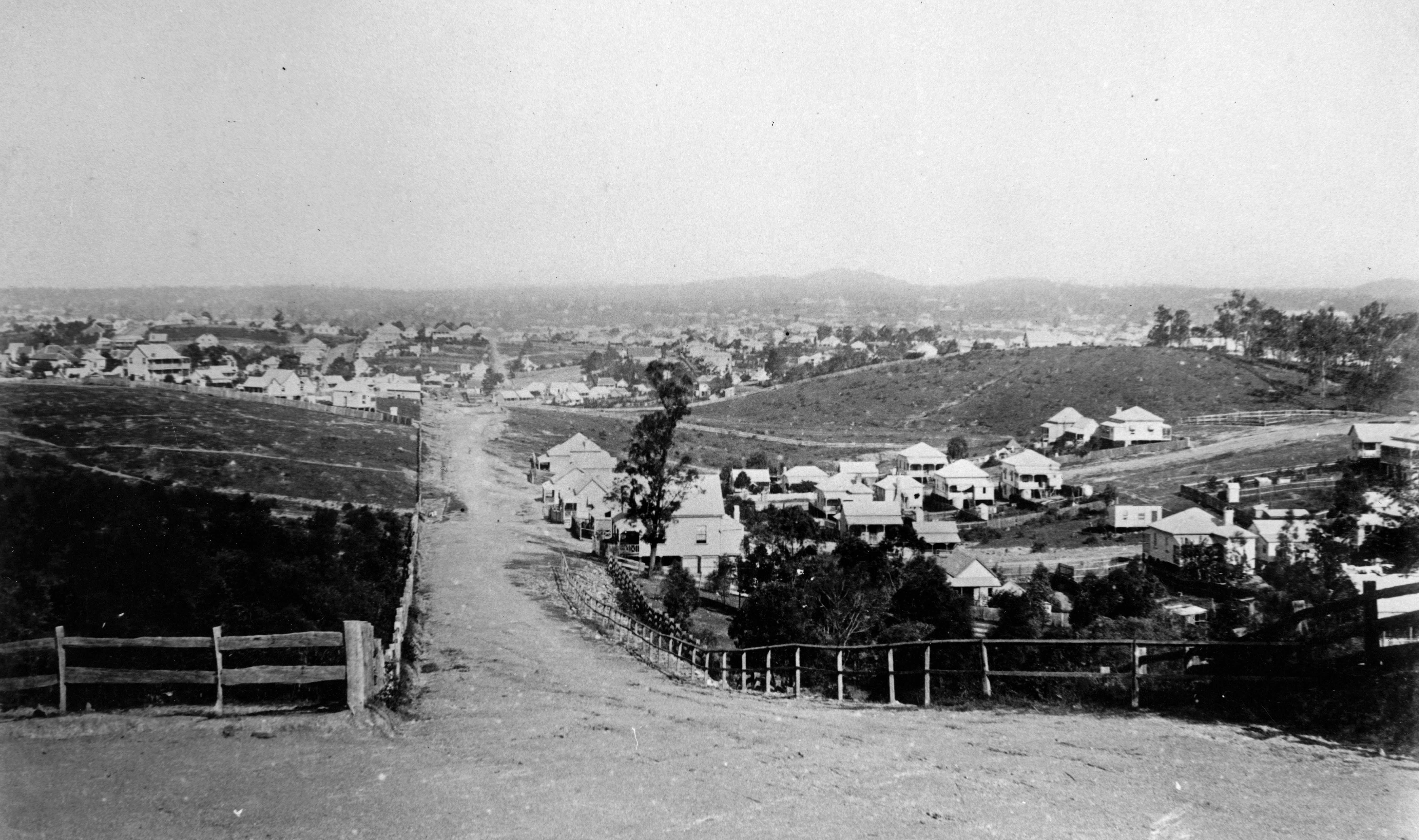
Looking down Gloucester Street from Gladstone Rd ca 1890, with the Beaumont Estate on the right and Stephens’ Paddock on the left. Subdivided land is slowly being developed. (State Library of Queensland)
With the increase in local population, shops started to appear from the late 1880s. Many have survived, and a number now serve as real estate agents, hair salons, restaurants, coffee shops and private homes.
John Jarrott in his booklet of memoirs recalls the free twist of boiled lollies for children that the grocery delivery man

This old Highgate Hill shop now serves as a residence.
brought with him in the 1920s. The delivery was from Larcombe’s shop halfway up Hampstead Road, which had been established by a previous owner around 1892.
Next door, a butcher shop was established by William Kneale in 1887. There was still a butcher shop there until recent years when it was incorporated into a new development. This was also the location of Highgate Hill’s first public telephone. (From Telegraph To Telephone) It appears in the 1910 telephone directory along with some 20 business and private services in the suburb. In 2020 there was still a public phone in this location.
Services
In the early days of settlement, firewood could be collected from surrounding undeveloped land. Gas reticulation, for domestic light and cooking as well as street lighting, was progressively extended from the late 1880s into the early 20th century. Electric power came to Highgate Hill in the wake of the approval by the State Government for the City Electric Light Company to proceed in South Brisbane in 1916. By the 1920s, home connection was common.
Looking down Dornoch Terrace in 1914. The road is unsealed and there is no electricity distribution. There are gas street lights. (State Library of Queensland)
Drainage remained an issue until the 1920s, as creeks still flowed along their old courses until the completion of large-scale storm water drains. (Kurilpa – Water, Water, Everywhere ) There was a footbridge in Emily Street over the creek that flowed down to the waterholes near Stephens Road until that time. During the 1920s, most streets were also sealed, curbed and channelled.
A sewerage scheme for Brisbane was first discussed in 1904, but construction didn’t commence in earnest

A Brisbane sanitation wagon (Brisbane City Council)
until the 1920s. This expensive work was delayed by the Depression and eventually became a work relief scheme. The night time visits of sanitation wagons largely stopped around 1933 when sewerage work was completed in most of Highgate Hill. Some difficult areas along the river remained un-sewered for decades after that.
Public Transport
A horse omnibus service operated to the corner of Brighton and Hampstead Roads from the late 1870s, followed later by a service along Gladstone Road( Brisbane’s Omnibuses , Omnibus Families of the Southside). The latter was replaced in 1901 by electric tram when the line was extended from Vulture Street to Dutton Park. In 1891, a train station was opened at Gloucester Street as part of the new southern suburban line. (Gloucester Street Railway Station)

One of James Clarke’s omnibuses that ran down Gladstone Rd., 1890. (State Library of Queensland)
Motor buses became common after World War 1, and by 1922 a privately run service was running from North Quay, travelling down Montague Road following the old horse omnibus route. ( Omnibus Families of the Southside) The route was extended up Dornoch Terrace in 1925, as a feeder to the West End tram line. In 1947, the route was taken over by the Brisbane City Council and became the number 29 Dornoch Terrace – Merthyr route, today followed in part by the 192 bus.

In this 1953 map, tram routes are shown in green and bus routes in red. (Brisbane City Council)
Education
Children of early European settlers in Highgate Hill such as the Wilson family ( Alexander Brown Wilson, Architect.) made their way into the city to attend the Normal School. In 1864, the South Brisbane School opened followed by the West End School in 1875 and the Woolloongabba School (now Dutton Park) in 1884. Highgate Hill children headed in different directions, depending on where in the suburb they lived.
There were also several private schools such as that run by Miss Denniss in Gertrude Street, “Crag Ha School” run by the Misses Potter for many years in Edmondstone Street and the South Brisbane High School and Kindergarten in Hampstead Road run by noted educationalist Marianne Brydon( Sheep, a House and Three Churches).
St. Killian’s Roman Catholic School located on Stephen’s Road was founded in 1873 but was badly damaged in a 1904 storm and wasn’t replaced until 1915, when St. Laurence’s School opened. In 1917, St. Ita’s Roman Catholic School opened and St. Francis’s School on Dornoch Terrace started in 1928.

Brisbane State High School under construction in 1924 (BCC archives )
Continuation of education past the 8 years to Scholarship level was largely restricted to those who could afford private education until classes commenced in various Schools of Arts such those at South Brisbane and West End ( The West End School of Arts). Later, the State Government took over further education and founded the Central Technical College on the site of today’s QUT. Secondary classes moved to the newly built Brisbane State High School at South Brisbane in 1925. Students looking for other than an academic education attended either Industrial or Commercial High in the city.
Recreation
Musgrave Park became a major location for sport and leisure activities towards the end of the 19th century. (Musgrave Park – The Early Days) Many Highgate Hill residents belonged to tennis, football, cricket, bowls and croquet clubs. Whilst long an informal picnic spot, Highgate Hill Park was purchased by the Council in 1903 and the shelter was erected in 1911. (Highgate Hill Park) The tramway company opened a leisure park at Dutton Park and along with other entertainment, motion pictures were shown there from 1909 until 1917 ( The Dutton Park Garden Theatre). Later a swimming pool was built on the river although it was never popular due to the effects of tides. Other swimming pools were located at Kurilpa Point and later Davies Park and Musgrave Park (Making a Splash – South Brisbane’s Early Swimming Baths).

Croquet players in Musgrave Park 1911. (State Library of Queensland).
In 1912 when Thomas Garrick established the Lyric Theatre on Boundary Street which continued as a movie theatre until it burnt down some 55 years later. His Rialto Theatre on Hardgrave Road operated as a cinema and live performance venue from 1923 until 1995. (Tom Garrick and his West End Theatres)
More recent times
The lower lying parts of the suburb between ridges grew more slowly than higher locations. Some paddocks were still being subdivided in the 1920s. Most remaining large estates were broken up over these years as well. (Westbourne St. 1930s Architecture)

Torbreck in 1960 (State Library of Queensland)
The 1920s also saw the beginnings of the construction of apartment buildings. Some large homes were divided up into flats as many wealthier residents moved to other locations. (Mon Abri – Brighton Road) After World War Two, migrants from Europe took advantage of low land values and settled in the area. Later, high rise residential development commenced, spearheaded in 1958 when construction of Torbeck on Dornoch Terrace started (The Three Torbrecks) This trend has continued unabated until the present time and most of the grand old houses that once characterised the area have now disappeared.
A few residents
Many interesting people have made their homes in Highgate Hill. Some of whom I have written about include the following:
Dr. A. Jeffris Turner – Paediatrician and medical researcher (Doctor A. Jefferis Turner – “Gentle Annie”
Ernie and Mabel Lane – Communist idealists and activists (Ernie and Mabel Lane – Radical Activists)
Douglas Price – Author and spiritual leader (Douglas Price – Tragic Modernist)
Daphne Mayo – Celebrated sculptor (Daphne Mayo – Brisbane Sculptor)
Ebenezer Thorne – Controversial journalist, alderman and serial bigamist. (The Enigmatic Ebenezer Thorne)
The Sankey and Fraser families. ( Sankey Street, Steeped in History)
References :
“Aboriginal Camp Sites of Greater Brisbane,” Dr Ray Kerkhove, Boolarong Press 2015.
“History of Highgate Hill”, John Keith Garret, Self-published 1997.
A 1930 history of Highgate Hill
© P. Granville 2023

HI Paul this is great research – I have emailed you a request the gmail – i hope you get it.
Carmel.
LikeLike
Great U3A talk Paul. Very pleased to get a link to this excellent blog.
LikeLike
Thanks very much.
LikeLike
Thanks for this excellent bit of local historical research.
LikeLike
Thanks Phil.
LikeLike
Hi Paul.
Great read my family lived on the corner of Dornoch and Dauphin. Brings back many memories.
Unfortunately units sit on our old block.
I’ll forward this to my brothers
Thanks
LikeLike
Thanks very much Alan . I remember when that row of houses was demolished.
LikeLike
Just discovered this blog. How fascinating . I’ve lived in Highgate Hill since 1988 and my husband since 1985. Thank you for all the hard work.
LikeLike
Thanks so much. I hope you have fun looking through my posts. Paul
LikeLike
Hi , I have lived in Highgate hill over 50 years . The Mens bora ring was opposite the petrol station just up from Brisbane State High School on the high road above. The last man alive from the Highgate Hill tribe put a curse on the land to never let anything be built on it.
In my life time 2 houses have burnt to the ground there (under mysterious circumstances ) and a swimming pool was put in but not used and filled in soon developers are going to build a building there , I would suggest not living there or buying that land.
Daphne Mayo lived in my house in Highgate Hill she put Australia on the map for Art and had also caved the intricate work on city hall and thr shrine of rememberance.
A future King visited Highgate Hill park .
Gladstone road is so wide because early cattle drovers would drive cattle to the ships bearthed near South Bank. When they moved cattle on mass they usually turned into Dornoch tce then went doen Hampstead road as that was the prefered route to drive huge masses of cattle.
I am on Facebook if you want more info on Highgate Hill as i know people who have early photos of a cattle drive on Gladstone Road ect..
LikeLike
Does anyone know about a house called St Adians on the corner of Gray Rd and Montague Road, My husbands Great Grandfather William Henry Bell lived there in the early 1900’s. He was a solicitor . His grandparents were married there in august 1915 and is mother was born there in 1918. I would love to see if I can acquire a photo of the house and some info on it. I believe it was a large circa style house.
LikeLike
Hi Paul, this is fascinating thank you.
I stumbled across your work during a renewed enthusiasm for finding out more information about my own home, ‘Inglenuek’ in Highgate Hill.
I have been trying for many years to find out more if its history (year it was built, who designed it etc) as it is a rather unique building. I found a little treasure trove a few years ago in the SLQ archives of a former owner J.A. Crawford which has multiple blueprints/documents/home video of my house from the 1940’s which I got a real kick out of. I believe he was a notable figure of the time?
The only other bits I’ve found are Newspaper adverts on Trove, from which I’m lead to believe J. W. Sutton (of Hurlton House) resided in his later years, until he passed away. This being true, it means the house must have been built sometime around the turn of the century (when we purchased it we were told it was built sometime in the 1930’s).
Would love to pick your brain to see if I can find out anything else.
LikeLiked by 1 person
Hi James I’d be happy to give you some ideas. It would be best if you sent me an email via the ‘Contact me’ feature of the blog . SLQ also has a good set of guides . https://www.slq.qld.gov.au/collections/queensland/built-heritage/house-histories
LikeLike
So pleased to find this site Paul. Our relatives, the Costins, lived in nos. 12 and 13 Norfolk Road. I was astounded to find out some time ago that the West End Osteopath Clinic where I have attended several times, was actually built by a member of our family.
I have recently joined the Annerley/Stephens History group as I have lived in the area since 1956.
Thank you for your very interesting stories. Jan Costin
LikeLiked by 1 person
Thanks Jan, I’m glad you have enjoyed reading some of my posts.
LikeLike