The Ridge
I began researching this post with the intention of writing the story of South Brisbane War Memorial Park. However the scope of my post soon expanded to include the interesting history of the long ridge on which the park is built. It provides a good example of how the landscape of Brisbane has been progressively transformed since European settlement.
Ham’s Map of the City of Brisbane from 1863 shows this ridge very clearly.

Extract from Ham’s Map of the City of Brisbane, 1863, showing the ridge with two houses, “Cooltigue” at the left and “Cumbooquepa” to the right. (Queensland State Archives)
The rocks which make up the ridge are known to geologists as the Neranleigh-Fernvale Metamorphics. They were formed through heat and pressure some 300 to 350 million years ago from more ancient rocks.
Aboriginal Camp Site
Our ridge was the location of a large habitual aboriginal camp site. Not far away were the river crossing point at today’s Kurilpa Park and pathways heading towards the south and east along what would become Cleveland and Logan Roads. Also nearby were bora grounds and a tournament ground near water holes in the vicinity of Leopard Street. The slopes of Highgate Hill were abundant hunting grounds.
A painting by Thomas Baines of the view from the ridge near today’s Dorchester Street clearly shows the Aboriginal camp still in existence in 1855.

“South Brisbane from the North Shore, Moreton Bay, Australia” Thomas Baines 1868, sketched July, 1855. (National Library of Australia)
Journalist Charles Melton writing as “Nut Quad” described the scene in the early 1850s.
“The site of the Dry Dock was occupied by a small but dense jungle scrub. whose giant vines stretched octopus-like arms around yellowwood, pine ,and fig. The native grape-vine grew in abundance, bearing clusters of small purple berries, which in season attracted wild pigeons from the hills beyond Coorparoo. Owing to the dense foliage overhead the sun’s rays never played upon
the little stream which purled over a pebbly bottom in the centre of the scrub, and which was fed by numerous tiny rivulets and waterfalls, which with sweet bell-like murmur tumbled down the rocky slope of forest-crowned Cumbooquepa – the hill on which now stands the palatial resilience of the late Mrs. T. B. Stephens and the South Brisbane Town Hall.”
European Settlement
After the convict period and the opening of Brisbane to free settlement, land in the area was sold progressively. Ham’s map above shows two houses on the ridge. To the west is “Cooltigue” built by William and Eliza Blakeney around 1862. I’ve written about the family in my post The Blakeneys of Highgate Hill .
The other house was built by politician, newspaper proprietor and businessman Thomas Blacket Stephens, who in 1865 was an early purchaser of over 100 acres in the area. Stephens built his home Cumbooquepa on the eastern end of the ridge. According to a 1923 newspaper article, the name derived from the water holes behind the house which were called “Cum-Cumbookie-bah” or “Place Where We Get Crayfish”.
They were located near where today can be found the Somerville House swimming pool. The water holes were fed by a creek which descended from Highgate Hill and flowed after rain into the large swamp in the area of Clarence Corner.
The waterholes are visible in the bottom right hand side of Ham’s map above.
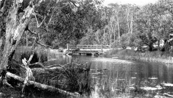
Creek and Bridge at Clarence Corner (from Memories along the Boggo Track by Annie Mackenzie )
The creek is remembered today by the naming of Brook Street. Adjacent Dorchester Street was originally called Water Street West.

The Entrance to old Cumbooquepa ca 1872. At the right can be seen a surveyor’s post marking the southern boundary of the Town of Brisbane. (State Library of Queensland)
The ‘Police in Town Act (Sydney) of 1833’ and further legislation was implemented in Brisbane over time to define the town’s boundaries, formed to the south by Vulture Street. The ironbark post visible to right in the photograph of old Cumbooquepa above was one of a number marking the town boundaries.
Aboriginal people were not allowed by police to remain within the boundaries after sunset. Thomas Stephen’s son William recalled in an interview “I can well recall that they (aboriginal people) had to get out of town at sundown and they used to camp at the waterholes at the back of our home in Vulture Street.”
The Ridge Begins to be Carved Up
I described the decision to build a railway line from Dutton Park to South Brisbane in my post Gloucester Street Railway Station. The route of the deep cutting through our ridge meant that old Cumbooquepa was demolished in 1890.


The Vulture Street railway cutting in 1890 and 2009.
By this time, Thomas Stephens had passed away and his son William built a new Cumbooquepa in 1890, a little to the east of the old house. Vulture Street at this time was little more than a narrow dirt track with numerous steep climbs, as it had been surveyed as a straight boundary to the Town of Brisbane without concession to terrain.
Looking up towards Vulture Street and the ridge from Grey Street in 1887. New Cumbooquepa is yet to be built. The prominent house “The Cliffs” sits on what will become known as “Gibraltar”. (State Library of Queensland)
Increasing traffic led to a decision to make a cutting through the ridge to flatten out the course of Vulture Street. This gave Cumbooquepa its characteristic cliff top appearance.

Cumbooquepa in 2019.
A substantial section of the ridge to the north of the cutting remained. It was given the nick-name of “Gibraltar”.

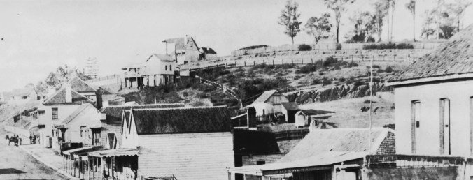
The 1888 view looking west along Vulture Street . A section of “Gibraltar” can be seen at the bottom right. (State Library of Queensland).
South Brisbane Development
In 1892, the South Brisbane Fire Station was built at the corner of Vulture and Sidon Streets, across the road from Cumbooquepa. It occupied the vacant land adjacent to the rock face at the right of the photo above, near the horse and dray.
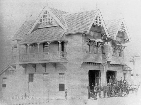
South Brisbane Fire station, Sidon Street, 1901. (State Library of Queensland)
In 1888, the steady increase in population south of the river led to the formation of a separate Borough of South Brisbane. No doubt the feeling of difference to the North Side as discussed in my post The Southside of Brisbane 1875 had some influence on the decision.
The new council spent £11,000 building the elegant South Brisbane Municipal Chambers. The architects were John Hall and Son, who were responsible for other notable South Brisbane builings as Burke’s Hotel, known as The Red Brick, and the now badly damaged Broadway Hotel.
The building was completed in 1892 and the electric clock, absent in the photo below, was added in 1904. The clock was built in Brisbane by the Synchronome Electrical Company of Australasia. They also made the Brisbane City Hall clock in 1930.

South Brisbane Municipal Chambers 1892. (State Library of Queensland)

William Stephens (Queensland State Archives).
The image shows that a further section of our ridge was removed to provide a flat base as a foundation for the Council Chambers. Also clear is that Cumbooquepa lost most of its front garden with the Vulture Street cutting. Interestingly William Stephens, owner of the house, was the Mayor of South Brisbane when the work was initiated by the Council.
The South Brisbane Post and Telegraph Office had been built nearby in 1881. It was closed in late 1889 and the building was successively home to the South Brisbane Mechanics Institute and Library, and South Brisbane Municipal Library and Technical College. A third stage comprising a concert hall was added to the rear in 1902.

South Brisbane Library and School of Arts, 1903. (State Library of Queensland)
As I was unable to find an image showing Vulture Street looking east, I’ve done a sketch showing how it may have looked around 1900. Only two lanes wide, the street passed through the cutting with remaining sections of the ridge on both sides.

My impression of Vulture Street looking east around 1900. The remaining ridge to the north of Vulture street slowly disappeared over the next 50 years.
The War Memorial Park
The precinct created by the buildings described above created the closest thing that the Town of South Brisbane had to a centre. Cumbooquepa had been purchased by the Presbyterian and Methodist Schools Association in 1919 and the other buildings continued as public facilities.
It was natural then that the adjacent large rocky outcrop known as “Gibraltar”, considered an eye-sore, was chosen as the location for the town’s principal War Memorial. The idea was first suggested in July 1919 with a petition of ratepayers asking for the council to purchase the land for £300. The idea grew from there with two separate groups, citizens and returned soldiers, raising funds and lobbying Council. They eventually combined their fund raising and lobbying activities in 1922.
Many fund raising methods were employed, including fetes, bowling contests, theatre parties, flower shows and dances.
The returned soldier group championed the idea of the building of an impressive and expensive memorial hall. Its construction may have changed the way the site subsequently developed over the years, as the widening of Vulture Street would have required its demolition. A sketch of the proposed hall was done by George Henry Male Addision, the architect who had also designed Cumbooquepa.
The five arches mirrored those on the facing façade of Cumbooquepa across the street.

Brisbane Courier, 11 November 1920.
However opinion was divided.

Daily Mail 23 February 1922. (TROVE)
Some councillors were against the whole idea of any memorial at all. The Council had barely enough funds to purchase the land which included four properties with 3 houses and a shop. Further, another memorial was being built in Mowbray Park.
By April 1922, a German 15cm howitzer captured by 26th Battalion near Villiers Bretonneux in 1918 was unveiled by the Governor, Sir Matthew Nathan, although little work had been done on the park.

The Memorial Park site in May, 1922. A captured German howitzer has been placed on a flat section near Vulture Street, but the rocky outcrop nicknamed “Gibraltar” remains along with the house called “The Cliffs” and other buildings. (State Library of Queensland)
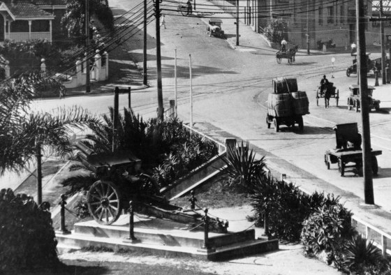
The German howitzer looking towards the corner of Vulture and Stanley Streets. (State Library of Queensland)
Also in April 1922, the final block of land had been purchased and a revised design for the park without a hall was proposed. Even so, public fund raising for a hall continued unabated for some years.
The Week (Brisbane) May 19, 1922. (TROVE)
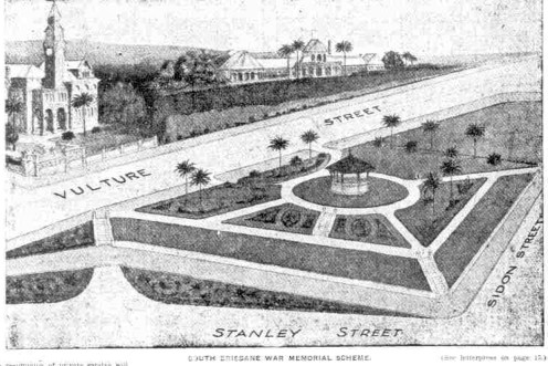
In the end, the Council did not have the funds to remove the large amount of rock required for this design and a revised plan with a gradual sloping of the land and a circular drive on the city side was adopted later in 1922.
The Governor-General Lord Forster officially opened the partially completed park in August of 1923 whilst on a visit to Brisbane. Work continued on and off as funds became available. As much as possible, unemployed returned diggers were employed in the work.
In 1927, the Fire Station was closed and removed, allowing the park to extend up to Sidon Street. However, by this stage the Town of South Brisbane had been incorporated into the new Greater Brisbane City Council and the park dropped in priority as funds were needed for completion of Anzac Square in the city.
Nevertheless with £80 of funds still available, the Park Committee proposed the erection of a set of Memorial Gates on the Vulture Street side and a statue on a plinth on the Stanley Street side. The Memorial Gates were eventually completed in 1934, but the statue had to wait much longer.

The park in 1948. (State Library of Queensland)
Over the years, the unfortunate location of the park adjacent to an ever busier Vulture Street took its toll. In 1952, a widening of the street from 2 to 4 lanes resulted in reduction of the park size as well as the disappearance of the last signs of the “Gibraltar” rock.
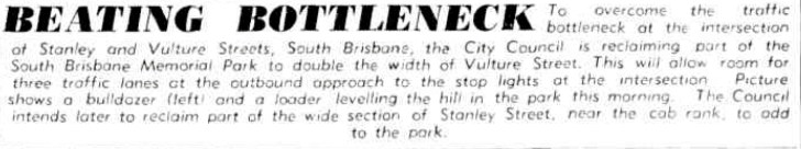
Brisbane Telegraph May 9 1952 (TROVE).


After completion of this work the park was at street level and “Gibraltar” had finally disappeared.

South Brisbane memorial Park after the 1952 levelling and street widening. (Brisbane City Council)
Further slices of the park were removed over the years with work related to Expo 88, a bus lane and the Children’s Hospital. The Memorial Gates were moved from the Vulture Street side down to the Stanley Street side of the park after road widening in the 1980s. Vulture Street is now seven lanes wide opposite the park, each additional lane having come from park land.
By the 1970s, the surrounding area was in a state of decay with largely abandoned buildings being graffitied and vandalised. The dry dock, library and the Ship Inn had all closed. The German howitzer had long been removed due to its poor condition.
Following Expo 88, the park’s fortunes slowly turned around with the development of the Southbank Parklands, the reopening of the Ship Inn and the completion of the Goodwill pedestrian bridge in 2001. The Maritime Museum took up residence in one of the pavilions built for Expo 88 as well as the adjacent unused dry dock. The year 2007 saw the opening of the Griffith University Film School in the old South Brisbane Library building.

One of the several memorials in the park.
The park now is home to a Bofors gun as well as several memorial plaques and monuments. Finally, in 2017 after rebuilding of the plinth that had been waiting for almost 100 years, a memorial statue honouring Royal Australian Navy personnel past and present was installed .


What a difference 40 years makes!


Thousands of commuters pass by everyday, walking between the Southbank Railway Station and the Goodwill Bridge, and few so much as glance sideways at the park. However there are visitors and quite often a park bench is occupied. Inquisitive tourists are frequently delighted to meet one of the many resident Water Dragons.
The little park and its surrounds certainly are redolent with the history of South Brisbane.
Further Reading :
Many thanks to the authors of the following references from which I drew ideas and information.
Indigenous Aboriginal Sites of Southside Brisbane (Dr. Ray Kerkhove)
South Brisbane Memorial Park: A Memorial to What? (Dr. Bill Metcalf)

Informative and well researched. You must thank Bill and Ray.
LikeLike
Pingback: The Southside of Brisbane 1875 | Highgate Hill and Its History
Pingback: Musgrave Park – The Early Days | Highgate Hill and Its History
Pingback: The Origins of Orleigh Park | Highgate Hill and Its History
Pingback: Vulture Street – From Dotted Line to Bitumen | Highgate Hill and Its History
Pingback: A Strawberry Afternoon Tea Highgate Hill 1905 | Highgate Hill and Its History
Excellent research of this south Brisbane area, to inform future residents of the colourful evolution of our city. Well done, if needs to be more well read by the community. Excellent piece.
LikeLike
Thanks Clive. I’ve found it takes a long time to build readership but I’m getting there.
LikeLike
Thanks for great stories and photo images – I am an architect at PDT Architects , originally Lange L Powell Dods Thorpe Architects started in 1938 local Brisbane firm + worked on EXPO & went to St Laurences – GEEZ this place has changed in my 65 year life too
LikeLiked by 1 person
Thanks Ray. I hope my occasional forays into architectural comment aren’t too far off the mark.
LikeLike