Few of those travelling up and down Dornoch Terrace realise that they are following a path that has been in use for tens of thousands of years. Since the arrival of Europeans , what was an Aboriginal pathway through the bush has been transformed to a rough dirt track, then to a genteel residential dress circle and finally to a heavily trafficked and at times dangerous thoroughfare. This is its story, divided into this post and Part 2 .
The ancient origins of Dornoch Terrace
In 1855, Surveyor John Galloway recorded Aboriginal pathways on a survey plan covering parts of the southside of Brisbane. When overlayed on a modern map, they illustrate how a number of major roads in the area developed from these pathways. Dornoch Terrace follows a path that at Binang-gurran branched off a main route to the Goodna district and followed the ridge down to the Kurilpa hunting ground.
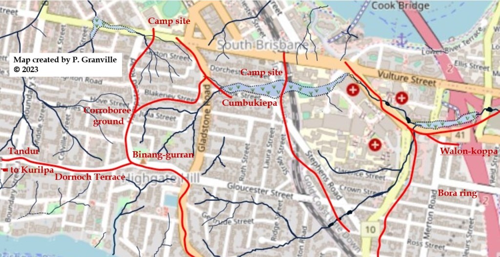
The place names and locations appear in the document “Aboriginal Place Names of Inner Brisbane”.
Kurilpa – place of rats
Tandur – Iron Bark
Binang-gurran – place of bearded dragon or high place
Cumbukiepa – place of yabbies
Walon-koppa – various meanings recorded eg. swirling water
A path becomes a track
A British convict colony was founded in Brisbane in 1825, but the pathway that was to become Dornoch Terrace remained largely undisturbed. The land between the ridge and the river began to be stripped of trees for use in construction and as firewood.
In 1842, Brisbane was opened to free European settlement, and surveying work commenced to allow the sale of land to settlers. On the southside, this was initially confined to the South Brisbane town area, Kangaroo Point, and farm blocks of fertile land along the Milton reach of the Brisbane River.

Being distant from the small settlement of South Brisbane and not suitable for farming, it wasn’t until the late 1850s that the land along the ridge was divided into portions of around 6 to 10 acres and sales began.

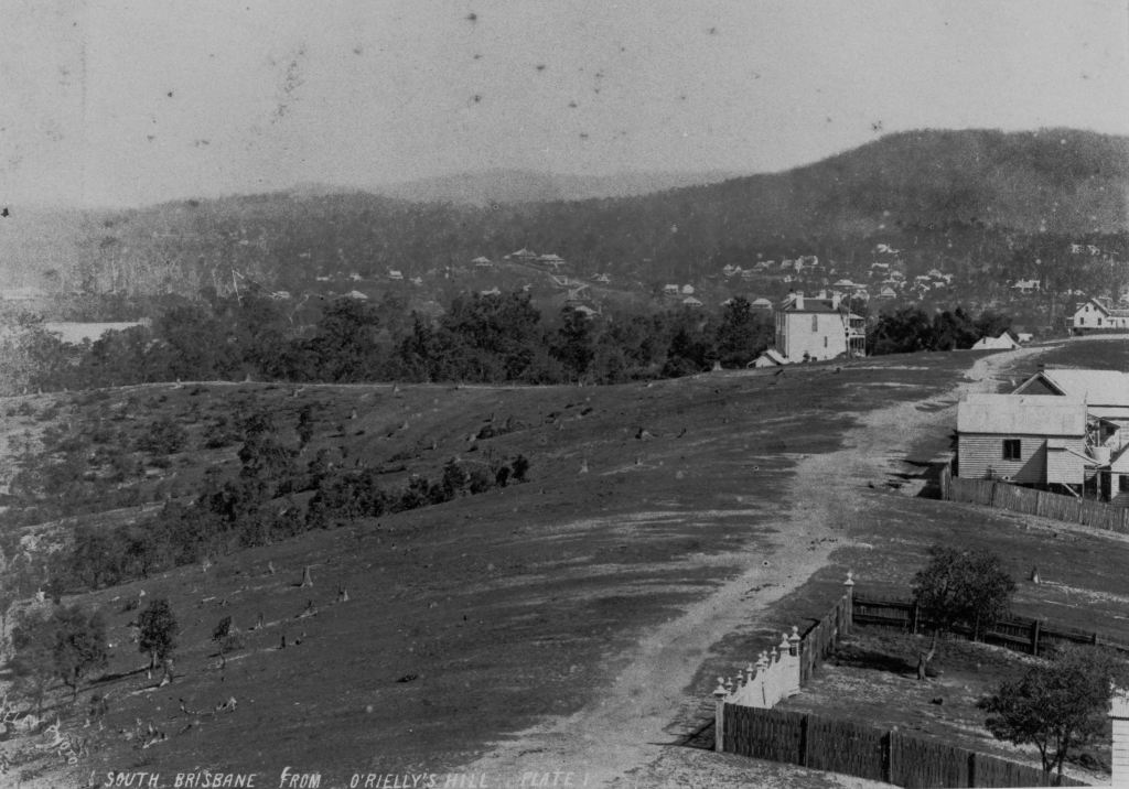
As depicted in an 1866 painting of a view from Highgate Hill by Joseph Backler, the Aboriginal pathways gradually transformed into wider dirt roads.

During the 1860s, some of the Highgate Hill area blocks were subdivided, but few homes were built, a major problem being the lack of water. One early sale in 1864 was a subdivision by Nehemiah Bartley of 21 lots in portion 155 on the crest of the hill, that he called the “Highgate Hill Estate”. Previously, as well as “Sierra Madre”, it had been referred to as “Bartley’s Hill”. From this time, the location was commonly called Highgate Hill.

By 1866, the new colony of Queensland had fallen into an economic depression, exacerbated by drought. The Bank of Queensland suspended operations. Many who had borrowed money to purchase land, such as Nehemiah Bartley, were forced to sell at bargain prices. The area was so lightly populated that a paddock on Dornoch Terrace near today’s Dauphin Terrace was leased by the Government for sheep quarantine from circa 1863 until 1877, seemingly without complaints.
A track gets a name
One of the first homes on the unnamed track was a brick cottage built by the Matheson family which stood near what today is the corner of Colville Street. Matheson was born in the town of Dornoch in Sutherland, Scotland. In 1865, Angus Matheson sold part of his 10 acre block to Alexander Macintosh, who came from Kinauld in the parish of Dornoch. The Macintosh family built their home on the land, calling it Kinauld.
All this strongly supports Florence Lord’s 1932 description of the two families jointly deciding to call the track Dornoch Terrace. The name Dornoch was thought for many years to come from the Gaelic Dorn-Eich meaning horse’s hoof. However, there is evidence that it may be of Norse origin.
The first mention of Dornoch Terrace in newspapers is in 1872, but it was not included in a post office directory until 1878 when McNaught’s directory referred to it as both Dornock (sic) Terrace and Street.
A slow start to suburbanisation
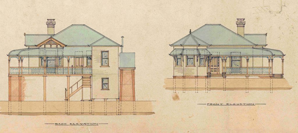
A notable early home built on Dornoch Terrace before it was named, and the oldest surviving dwelling, is Toonarbin, built by Captain Henry O’Reilly probably in the late 1860s, although it doesn’t appear in a Post Office Directory until 1876. You can read some of its history in my post “Toonarbin“.
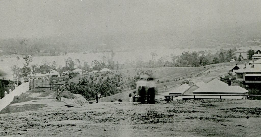
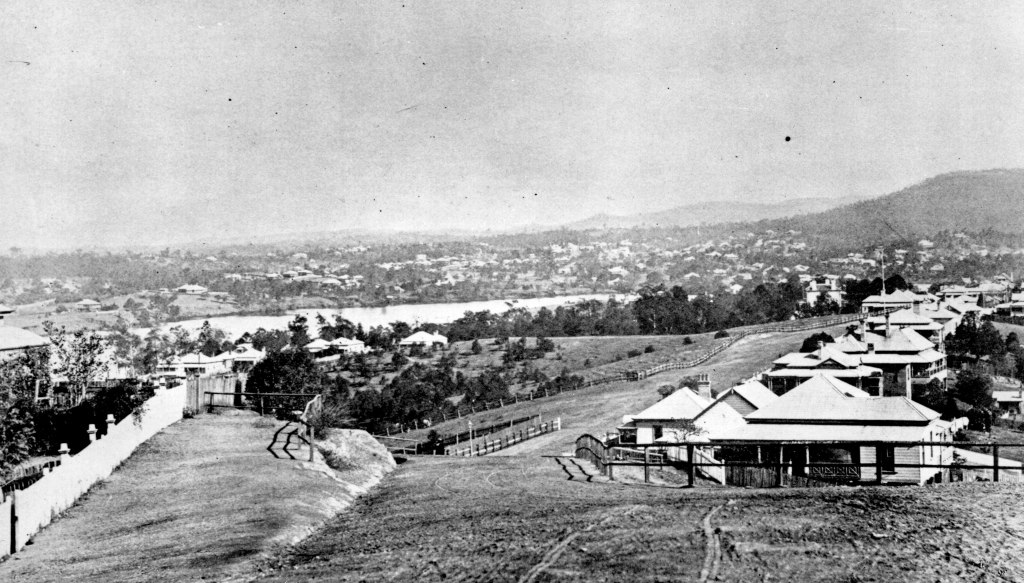
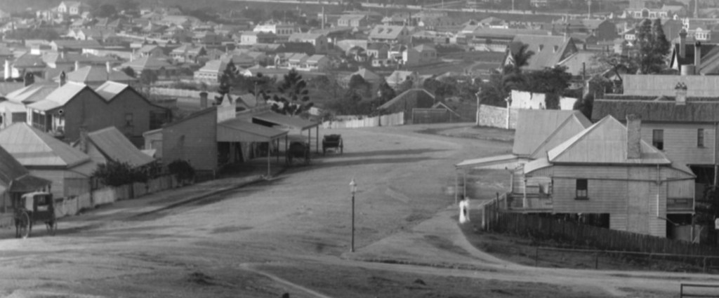
By the time that the photograph above was taken in 1884, the Post Office Directory listed just 6 homes on Dornoch Terrace. At the top of the hill stood the Fraser family home Torbreck which was built in around 1876, and demolished to make way for the high rise building of the same name in 1958. See my post “The Three Torbrecks” for more detail.
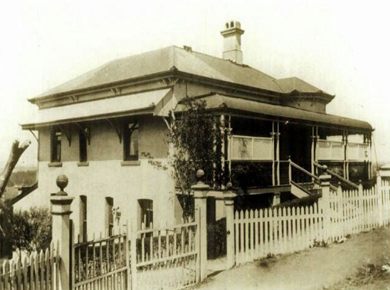
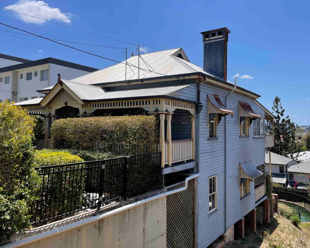
Further down the hill, in 1883 Glenview had been built as a rental property by carpenter Henry Smith. I’ve written about this house, our home, in another post. Nearby stood the original Kinauld, which in 1888 Catherine Macintosh, who had been widowed in 1877, replaced with the current house.


As well as the O’Reillys in Toonarbin, there were two other residents in 1884: William Gibson a drayman and George Newman a trustee in insolvency, and their houses are probably no longer standing.
The late 19th century
Over the remaining years of the 19th century, there was a slow growth in houses on Dornoch Terrace. Queensland had entered into a prolonged depression in the 1890s, during which time the building industry was almost at a standstill.
1889 saw the completion of the Highgate Hill service reservoir , which provided a satisfactory reticulated water supply for the first time, removing a significant barrier to growth and greatly assisting the fire brigade quell all too frequent fires.
The West End Gas Works commenced operation in 1885 and a further fillip to growth was the running of a gas main down Dornoch Terrace in 1889.
Whilst a number of substantial homes were built in this period, the post office directories show a wide range of occupations in its residents. Not only well-to-do merchants and senior public servants made their homes here, but also gardeners, carpenters, painters and bricklayers.
In 1899, a large block of land along Dornoch Terrace, comprising 90 allotments bordered by Hardgrave Road and Bristol and Katrine Streets, came up for sale. The advertisement waxed lyrical about the location.
“… it is in the City, not in the Bush, and yet, While having all the advantages of Town life, it has all the pleasures of Country associations-the sinuous reaches of the Brisbane River, the grand mountainous
scenery in the distance, and the sylvan glades, rural retreat, and mossy dell of the localities immediately adjoining it.”
A selection of surviving houses from the period 1890-1910
Well known Queen Street tobacconist James Aitchison built Beechview at number 36 in around 1892. In 1898 the family decided to return to Scotland and sold the house as well as all of the furnishings. The extensive list of items for sale included
Splendid Solid Walnut Inlaid Frames Drawing-room Suite, comprising 9 pieces, richly upholstered in Genoa velvet ; Large and Elaborate Queen Ann Cabinet in rosewood, inlaid with 20 bevelled mirrors ; Sweet-toned and Powerful American Organ, 11 stops, by the celebrated makers, Hurst & Co., Boston.
The house was then purchased by the Crowther family. Samuel Crowther was a part owner of the Dominion Milling Company. The Aitchisons returned from Glasgow after some years. William resumed his business, and lived in Edelweiss that stood at 120 Dornoch Terrace.

John and Marie Rumpf emigrated to Australia from Germany in 1863, went into shop keeping, and later ran a number of hotels including for a period the ‘Ship Inn’ at South Brisbane. In 1893, they moved into their new home, Karlsruhe, on the peak of Highgate Hill at number 165.

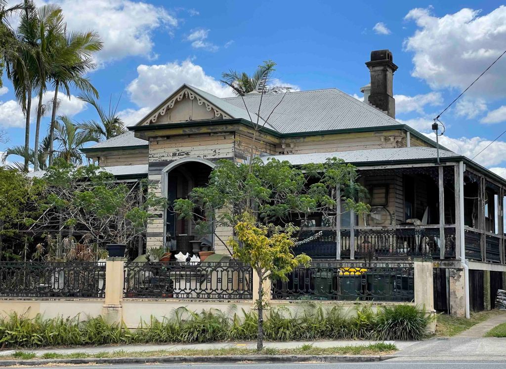
Other long term residents include the Thompson family who called the house Daar Lodge and owned bookshops and the Hegerty family who were involved in horse racing and named the house Rodmaun. In the 1990s, it was well known as a party house and a centre of political activism. My post Beer, Books and a Bookie – the Story of a Highgate Hill House relates the full story of this dwelling and its occupants.
Stranville at 22 Dornoch Terrace was built by Eleanor and William Mayes, warehouseman, circa 1901. For some 31 years from the 1920s it was the home of Christina and dentist Thomas Ferguson. In 1929, their neighbours Valerie, Edith and Wanda Ruthning took Ferguson to the Queensland Supreme Court to seek an injunction forbidding him to keep roosters on his property.
The Ruthning sisters were successful, but Ferguson appealed the decision and won.
The Ruthnings then attempted to take the issue to the High Court of Australia, which refused to hear the case. Mr. Justice Isaacs, later Governor-General Sir Isaac Isaacs, stated : “There is no question of law to be argued. It is merely a question of the preternatural vocal vigour of these roosters and the sensitivity of these ladies.”
By the 1990s, as the Flamingo House community centre, it was used by Vulcana Women’s Circus, West End Activists and Volunteers Etc (WEAVE), Friends of the Earth, ‘Connect’ youth action group, the Starving Artists Collective, Self Employment and Enterprise Development Scheme (SEEDS), Nature’s Children Organic Food Buying Group, Yoghurt youth culture magazine plus a variety of music, film and specialist library events.
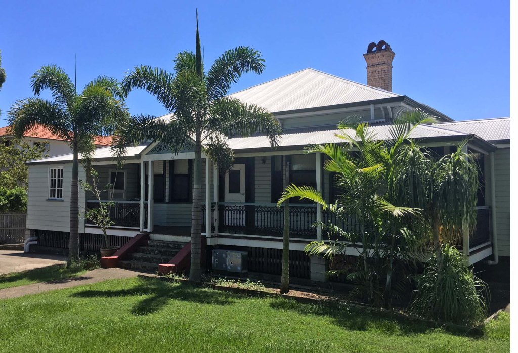
The house Dandenong at number 90 was built ca. 1906 by the Nichol family.
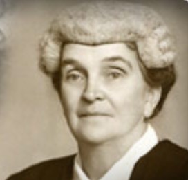
Dandenong was the home of Charles and Irene Trewin for about 35 years from 1937. Irene (nee Paten) won a scholarship to attend Trinity College at the University of Melbourne. She graduated in law in 1912 but as a woman was unable to serve her articles in Brisbane, and so returned to Melbourne. She was admitted to the bar of the Supreme Court of Victoria and the High Court of Australia on 1 December 1914, becoming Queensland’s first female barrister.
Although she never practised law, she was very active in community affairs and in the education of women regarding their legal rights. She actively promoted women becoming involved in public life.
The Dornoch Terrace Bridge
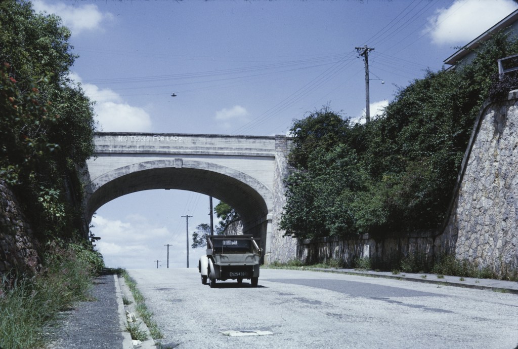
After houses began to be built between Dornoch Terrace and the river, access was via Boundary Street, which required a steep and difficult climb by foot or horse drawn vehicle. From around 1886, local residents lobbied the local council, then the Woolloongabba Divisional Board, to flatten Boundary Street.

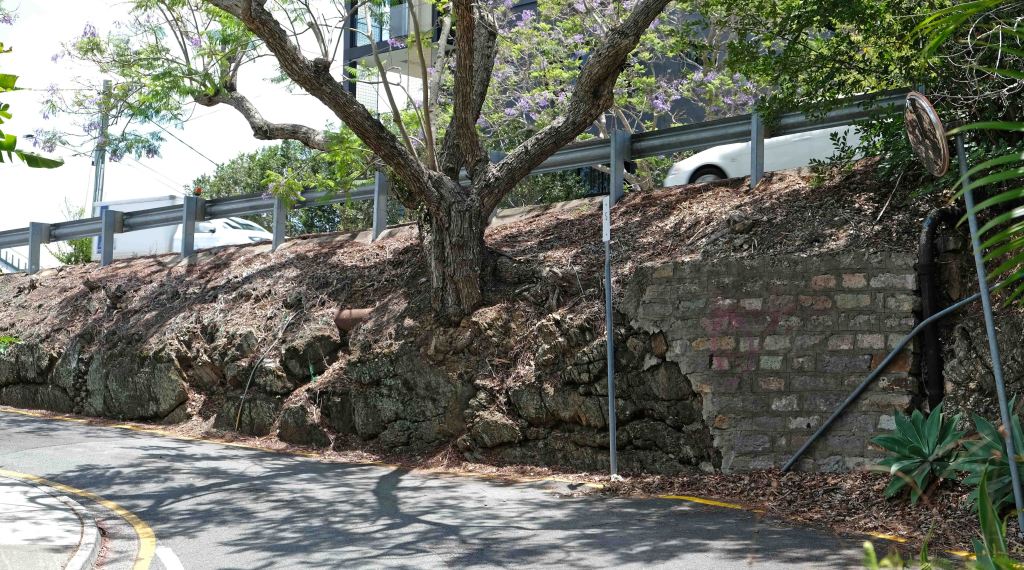
Work to make a cutting through the ridge and a bridge on Dornoch Terrace was completed in 1888. A slip road was built parallel to Dornoch Terrace allowing traffic from Boundary Street to access the higher level of the Terrace. Two late Victorian houses of similar design Rocky Nook and Campania are perched on top of the cutting.

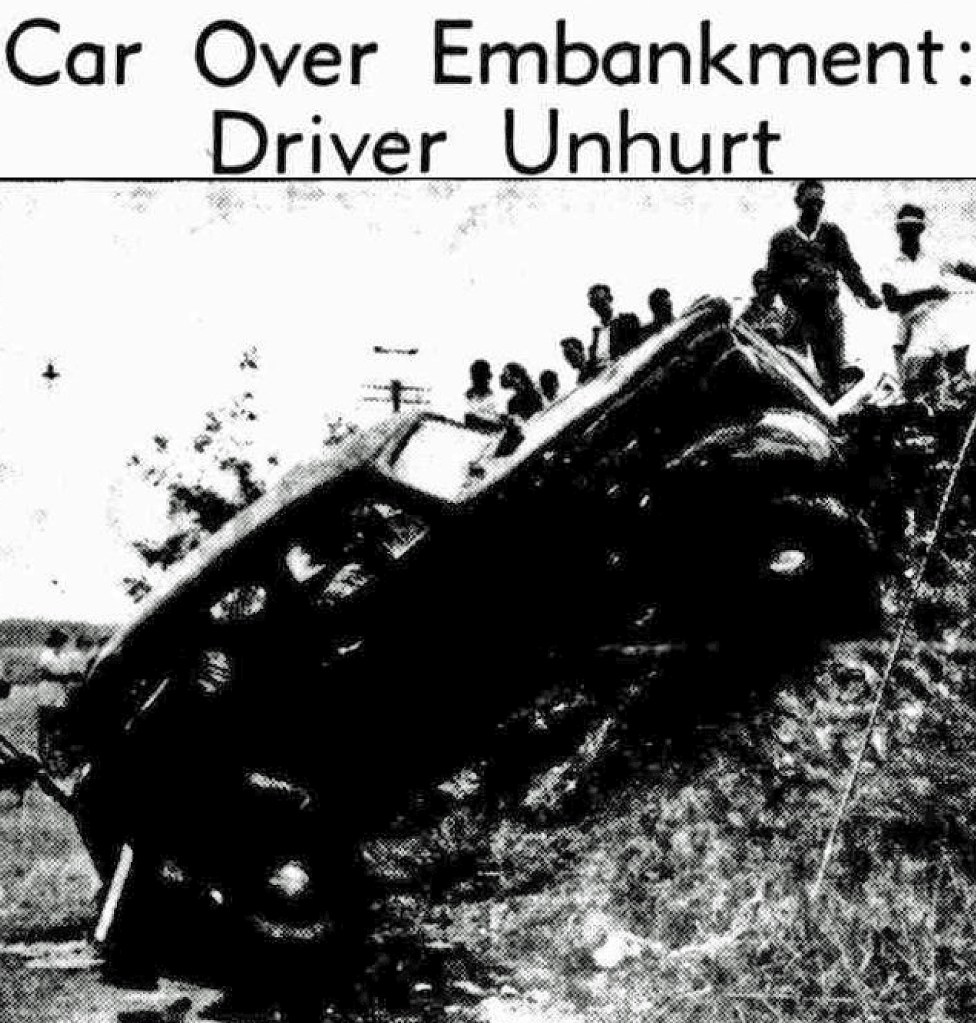
The drop from Dornoch Terrace occasionally caused some problems such as that in the image below.
A plan to build a bridge across the river to the new university at St. Lucia entailed widening and heightening the cutting. This work was completed in 1940 but the bridge was never built.

For the full story, see my post The Dornoch Terrace Bridge.
Dornoch Terrace at the turn of the century
The 1901 Post Office Directory lists 33 homes on Dornoch Terrace, although some would have been located on yet to be created side streets. Of the 33, 21 were on the mostly less steep north side.
A new feature visible in the image above is the gas street light located near the fence line in the centre of the image. This was undoubtedly placed there to reduce the risk of vehicles tumbling over the steep drop where St. James Street now dog-legs down.
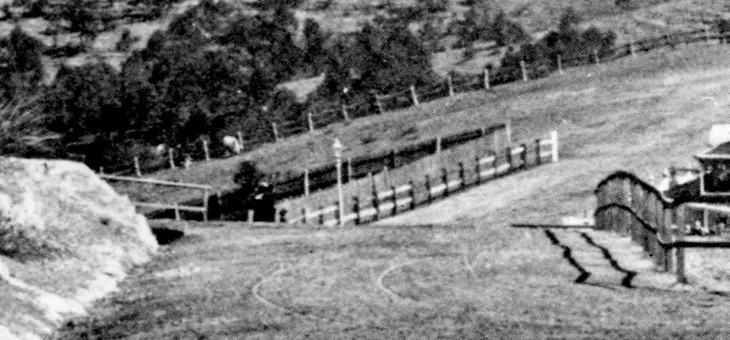
Occasionally, accidents have occurred at this point on Dornoch Terrace.


Shops
With the local population steadily increasing, shops started to appear from the late 1880s. Dornoch Terrace residents could visit either of the groups of shops at the Gladstone and Hardgrave Road corners or shops on side streets.
John Jarrott in his booklet of memoirs recalls the free twist of boiled lollies for children that the grocery delivery man brought with him in the 1920s. The delivery was from Larcombe’s shop halfway up Hampstead Road, and had been established by a previous owner around 1892.
As well as shop deliveries, there was also a variety of other vendors who sold commodities such as milk, bread, ice and fruit and vegetables door to door. We had home delivery of milk to our house in Dornoch Terrace up until the 1990s.

With the advent of supermarkets and increased car ownership in the 1950s, over time most corner shops closed.


Many have survived, and a number now serve new purposes such as real estate agents, hair salons, restaurants, coffee shops and private homes.

In Part 2 of my overview of the history of Dornoch Terrace, I look at the profound changes of the 20th century and recent decades.
Notes
- In the past, I have obtained numerous historic property titles to add accuracy to posts of this nature, such as for example, A Walk Down Norfolk Road. However, the Titles Office has now been corporatised and prices have increased. The last quote I obtained for a single title was $157.46 compared to the previous cost of $21.67, making it too expensive for my non profit endeavours.
- House names were the only method of identification until street numbering was introduced on Dornoch Terrace in 1936.
Dornoch Terrace Heritage Listings
The 1.3km of Dornoch Terrace is the location of no fewer than 16 heritage listings.
- Former Methodist Church 19 Dornoch Terrace
- Flamingo House 22 Dornoch Terrace
- St. Francis School and Church
- Toonarbin
- St Francis Presbytery 59 Dornoch Terrace.
- Dornoch Terrace Bridge
- 81 Dornoch Terrace
- Cleona 100 Dornoch Terrace
- Kinauld 116 Dornoch Terrace
- Carinya 117 Dornoch Terrace
- Lutmis 121 Dornoch Terrace
- Glenview 132 Dornoch Terrace
- 147 Dornoch Terrace
- Highgate Hill Park
- Torbreck 182 Dornoch Terrace
- Fire Hydrant outside 191 Dornoch Terrace
© P. Granville 2024

As always, Paul, a brilliant piece of work.
Bill
Dr William J Metcalf
Adjunct Lecturer, Griffith University,
Honorary Associate Professor, University of Queensland,
Brisbane, Australia
LikeLiked by 1 person
Thanks very much for your kind words Bill
LikeLike
Thanks Paul. I really enjoyed the read and the photos. It will enrich my future walks along Dornoch Tce!
Cheers,
Helen
17 Skinner St
West End
Sent from my Galaxy
LikeLiked by 1 person
Thanks Helen . Pity about about the traffic !
LikeLike
Very interesting – would love to do a walking tour down Dornoch and have this history explained in more detail of the houses remaining.
LikeLiked by 1 person
I have published a self guided walking tour of the suburbs which you’ll find in my blog site .
LikeLike
Hi Paul
Thanks for another interesting article. You have included a photo, maybe cropped, looking north down Hampstead Road. Can I rely on it’s date of ‘c.1892’? I have a copy of the same photo, taken from the top of Hampstead Road, which lacks the detail of the shops and carts and the houses still standing near Hove street and opposite. My date is 1915 so I’m confused. The single public gas lamp and the small girl standing at the side of the road confirms the common origin of the photographs.
Thanks,
John Cleary,
55 Hampstead Road
(our home was originally two shops, being replaced by flats in 1974 which became our home in 2006.)
LikeLike
Hi John, the image is from the George Washington Wilson Collection held by the University of Aberdeen. Judging from other images taken in Brisbane in this collection it is probably ca. 1892 but definitely in the first half of the 1890s.
https://abdn.primo.exlibrisgroup.com/discovery/fulldisplay?docid=alma9917857857405941&context=L&vid=44ABE_INST:44ABE_VU1&lang=en&adaptor=Local%20Search%20Engine&query=any,contains,brisbane
LikeLike
Hi again John, I just zoomed into the photo and you can clearly see in the distance the intact first Victoria Bridge, which places the image before the February 1893 flood.
LikeLike
Hi Paul!
I am working on a heritage report for the old Methodist Church at the end of Dornoch Street, and this has been a fantastically helpful resource for the early history of the wider area.
I was wondering where you sourced your Galloway 1885 survey maps from?
LikeLiked by 1 person
Hi Codee, I think you mean the 1855 map unless zi made a typo in the post. It took me about 20 years to track down. Eventually the curator at the Lands and Mapping Museum found it for me. I can send you a copy but you’ll need to use the ‘Contact me’ function in the menu to establish email contact.
LikeLike