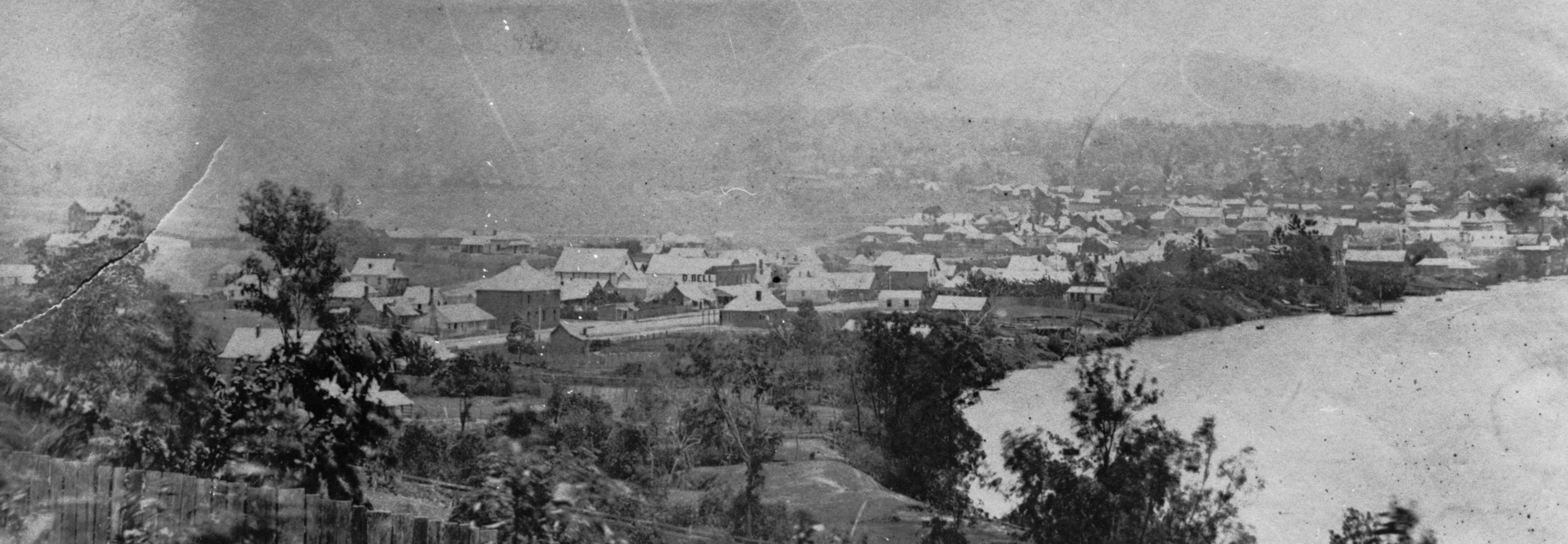
The first land sale
Some 17 years after the British convict settlement at Redcliffe was moved to the site of Brisbane in 1825, Moreton Bay was opened to free European settlement. The first land sale was held in Sydney in July of 1842 with blocks both north and south of the river on offer. Whilst the 8 allotments in what is today the centre of the CBD sold at much higher prices than expected, the sixteen in South Brisbane fetched lower but still respectable amounts between £30 and £150. The land sold is now occupied by the Performing Arts Centre and the South Brisbane Railway Station.
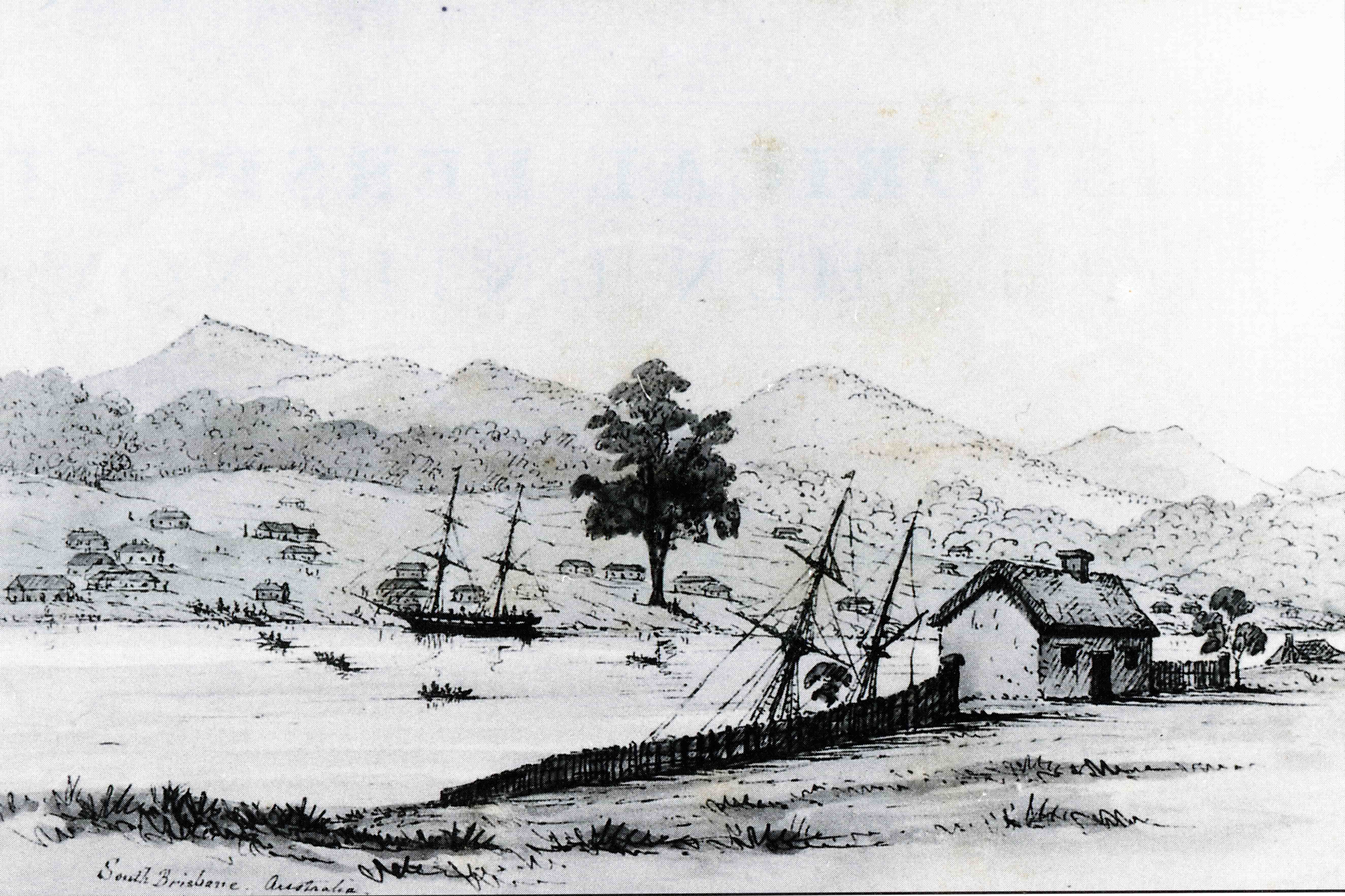
A report of the sale criticised the sale of the South Brisbane land mentioning that the lots, bought sight unseen by most, were unsuitable because they were “situated in a swamp which is overflowed daily, at highwater”. For more on the water problems of South Brisbane, see my post Kurilpa – Water, Water, Everywhere.
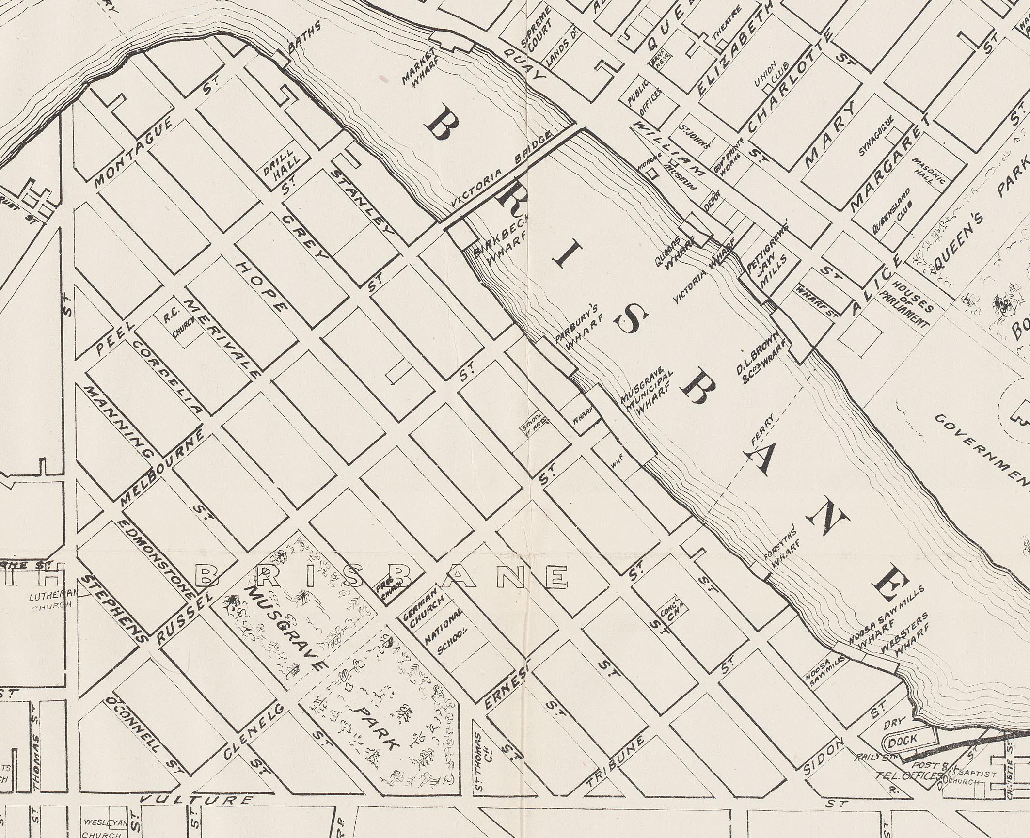
The land sale required the surveying and naming of streets. As is well known, the streets north of the river were named after members of the British royal family. South of the river, the names of members of aristocratic government ministers were used.

Naming South Brisbane’s first streets

The riverfront was named Stanley Quay, after Edward Smith-Stanley, the 14th Earl of Derby and Secretary of State for War and the Colonies in the period from 1841 to 1845. Later, land along the river was sold to allow the development of private wharves. This included the three lots purchased by the Hockings brothers in 1849 as described in my post Alfred Hockings and his “Rosaville” Nursery. Subsequently, the “proposed road” on the map above became known as Stanley Street.
Grey Street was named after either Charles Grey 2nd Earl Grey who served as Prime Minister between 1830 and 1834, or his son Henry Grey, 3rd Earl Grey who had been Secretary at War and from 1846 Colonial Secretary. Others of these first South Brisbane streets were named after William Lamb, 2nd Viscount Melbourne who was Prime Minister from 1835 to 1841, Sir Robert Peel who was Prime Minister for two terms, Lord John Russell, Secretary of State for the Colonies 1839-1841 and later Prime Minister, George William Hope who was Under-Secretary of State for War and the Colonies at the time the streets were named and Charles Grant Baron Glenelg who was an earlier Secretary of State for the Colonies.
More early street names
As South Brisbane grew, further streets were added to the grid pattern and the South Brisbane Reserve was also formalised. It was later named Musgrave Park (see my post Musgrave Park – The Early Days).


Merivale Street was named for an administrator rather than a politician. Herman Merivale was professor of political economy at Oxford who published a series of lectures on colonies and colonisation from around 1840. He subsequently worked as permanent under-secretary in the Colonial Office from 1847 to 1860.
Ernest Street perhaps recognises Prince Ernest II, Duke of Saxe-Coburg Gotha and elder brother of Queen Victoria’s consort, Prince Albert.
Continuing with a penchant for patriotism, a group of streets in the south-eastern corner of South Brisbane were all named after Royal Navy ships that served in the Crimean War, which took place between 1853 and 1856. These included Tribune, Sidon and Odin streets as well as Leopard Street which is off the map above, near Kangaroo Point.
At the same time, the adjacent southern town boundary of Brisbane was dubbed Vulture Street (see my post Vulture Street – From Dotted Line to Bitumen) after another of these ships. All still exist except for Odin Street, which was realigned after the graving dock was constructed and renamed Dock Street.
I’ll return to Montague Street, located at the top of the map, later in this post.
The 1860s
On the 1858 map above, a number of planned streets inside the town boundary formed by Vulture and Boundary Streets were yet to be named. In 1859, the Municipality of Brisbane was incorporated and Queensland became a separate colony. Street names began to take on a more local flavour. The responsibility for the naming of streets as well as place names fell to the first Queensland Commissioner of Crown Lands and Surveyor General, explorer, geologist and surveyor Augustus Charles Gregory.

In 1864, for example, Edmonstone Street appears in land sale notices. George Edmondstone arrived in Brisbane in 1842 and established a butchery business. He became quite wealthy and entered politics, serving as an alderman. He was mayor in 1863 in a difficult period of negotiation with the Queensland Government regarding the building of the first Victoria Bridge (see my post The Fascinating Story of the First Victoria Bridge).
Nearby O’Connell Street was probably named for Maurice Charles O’Connell who was president of the Legislative Council, Queensland’s now defunct upper house, from 1860 to 1879. He also acted as administrator during various periods between the departure and arrival of Queensland Governors.
Interestingly, in 1877 during one of these periods, Edmondstone was nominated for membership of the Legislative Council, which was not an elected body, by premier John Douglas. However this was opposed by O’Connell and Edmondstone’s appointment had to wait until the arrival of the new Governor, Arthur Kennedy.
In the 1860s, Queensland’s first governor George Bowen wrote a number of notes to Surveyor General Gregory suggesting names for new Brisbane streets. In one undated letter from around 1862, Bowen proposed that
“if the new street by the reservoir has no name yet, I would suggest “Roma” – Lady Bowen was Countess Roma by birth” .


In another note dated January 1862, he suggested that two new streets in South Brisbane be named after HMS Cordelia, which served on the Australian Station from 1859 until 1862, and her captain, Commander Charles Egerton Harcourt-Vernon. The Cordelia was the ship which transported Bowen and his family to Brisbane in 1959. Specifically, he proposed that Boundary Street be renamed Cordelia Street.
Whilst Gregory accepted use of the names, a pencil note on the back of the letter, presumably written by him, says
“Cordelia 1st st parallel to Merivale St and Vernon 2nd do.” (sic)
Whilst the first street parallel to Merivale is named Cordelia, the second has been known as Manning Street since at least 1864. There is a Harcourt Street in Fortitude Valley which is also mentioned from 1864 and nearby is Vernon Terrace which seems to have been named, perhaps coincidentally, some years later.

Manning Street is named for Arthur Wilcox Manning, who as Under Secretary of the Queensland Chief Secretary’s (Premier’s) Office was a very senior public servant. He had wide powers, including the appointment of magistrates.

In 1869, Frank Bowerman was the clerk of petty sessions at Nanango and had been recently demoted from the position of magistrate at Leyburn after the discovery of an alleged misappropriation of funds. Bowerman decided to travel to Brisbane to speak personally to Manning about the issue and to request an advance in salary to repay the money. The meeting did not go well and Bowerman left the office, purchased a tomahawk in Queen Street, and a few hours later, returned with it hidden beneath his coat.
Bowerman asked Manning to read a letter from his wife, which pleaded for clemency. When he refused, Bowerman pulled out the tomahawk and chopped at Manning’s head.
In an atmosphere of great outrage, Bowerman was tried and given a life sentence, considered even at the time to be excessive. Parliament quickly passed legislation granting Manning a very large annual pension of £700, his full salary, half of which was to continue to be paid to his widow on his death. It was thought that he would not live for long due to the injuries he had received.
Manning soon retired and lived for thirty years after the attack, by which time he had reached the age of 80. Bowerman’s wife Cordelia fought for years for her husband’s early release, even meeting fruitlessly with Manning asking for his support, given his injuries were in fact minor.

Bowerman was finally released, having been incarcerated on St. Helena for 9 years. Cordelia died the day he was released. Bowerman committed suicide in Sydney in 1894.
Later street names
Later, street names came from a wide variety of sources. The names of prominent local residents were sometimes used such as for Hockings Street, which was adjacent to the large nursery established by that family along Montague Road in the 1850s ( Alfred Hockings and his “Rosaville” Nursery ).
Natural and man made features gave rise to names such as Water, Spring and Ferry Streets. When suburban subdivision commenced, often the family name of the developer or land owner was used. Brereton Street, for example, was named for Sydney based doctor and homœopath John Le Gay Brereton who owned the surrounding land for some years before its subdivision in 1885.

Some of the street names on this map will be unfamiliar, as there have been ongoing changes over the years. For example, in 1950 three in South Brisbane were changed.
Stephens Street, probably named for mayor, business man and extensive land owner Thomas Blacket Stephens, was changed to Mott Street. A few months later it was changed again to Browning Street. Possibly this was because after Mott Street in Gaythorne was changed to Brin Street at about the same time, there were so many complaints from residents that it was changed back again!
In the same year, South Glenelg Street became Besant Street and the southern fragment of Hope Street, which had largely disappeared under the railway extension in 1891, was renamed Colchester Street. Unfortunately related council files giving background to these changes do not seem to have survived. However, Besant Street was perhaps named after educationalist, activist and philanthropist Annie Besant. Although she died in 1933, there were still frequent mentions of her life in newspapers in the 1950s and the Theosophical Society named their building on Wickham Terrace “Besant House”.
Montague Road
But what about Montague Street? It first appears in 1851 land sales as the name of the northernmost cross street of the original South Brisbane grid.

A road which led from the end of Montague Street was simply referred to as “Government Road” which was the general term in use for unnamed thoroughfares, and on some maps it was shown as Hill End Road. It led to the property of John Perril Wilke which he had named “Hill End” (see my post The Origins of Orleigh Park ). From the 1860s, the extension became known as Montague Road.
Unlike other early South Brisbane streets, the origin of the name is not obvious. The only mention of a Montague at that time that I could find was a report in a Sydney newspaper of an 1850 debate in the House of Lords concerning the Australian Colonies Government Act. This legislation created the Colony of Victoria and established the framework for the future separation of other colonies from New South Wales.
Initially the draft legislation specified a single house of parliament in each colony. A Lord Montague is reported moving a successful amendment to have a Legislative Council upper house as well as an elected Legislative Assembly. This certainly would have made him popular with the colonial elite, as the upper houses were composed of members appointed for life by the Governor.
But who was this Lord Montague? Hansard records for the House of Lords are online and I located the debate which took place in June of 1850. However the amendment was moved by Lord Monteagle. Could it be that Montague Road is named after a typographical error ?

In 1909, the South Brisbane Council proposed many changes to streets, including renaming Montague Road as Davies Road in honour of John Davies (see my post The Davies Park Story ) but this and many other of the proposals never eventuated.

© P. Granville 2021

Paul,
Superb fact fining and well presumed assumptions.
I was intrigued by the derivation of names for the couplet of Manning (named after a Qld. colonial public servant) and Cordelia (named after a Royal Navy ship) and then with the coincidental pairing of the said Arthur Wilcox Manning and ‘Cordelia’ Bowerman, wife of the man who attempted to tomahawk Arthur’s head into a pulp…yes, South Brisbane has lost its earthiness!! …and I’ll never again feel quite the same way…when turning out of Cordelia, at Russell Street…..and using Manning to ‘axe’ some time from my trip to Coles in the West End Markets at the corner of Boundary and Mollison!
Keep up the wonderful story telling and when are you going to turn it all into one big compendium and offer your work as a glossy hardcover book?
jac
4/12/21
LikeLiked by 1 person
Hi Jac
Thanks very much for your comment. I was ‘struck’ by the Cordelia Coincidence as well . I do have a dream of turning it all into a book but I keep uncovering more material!
Paul
LikeLike
Great story, keep up the good work.
LikeLiked by 1 person
Dear Paul
Thank you for your very informative & interesting blog.
I have a great, great grandfather William George Emerick who fought in the Crimean war then migrated to Queensland in 1865. He must have settled for a short time in South Brisbane as one child, Mary, died at a residence in Stanley St. & my great grandmother, Eleanor, was born in 1867 in Russell St.
William George may well have recognised the names of Royal Navy vessels from the Crimean War.
I thought that an interesting connection to my family tree.
The family moved to the Darling Downs then Stanthorpe for the tin mining boom in 1874.
I have enjoyed the other blogs & the website.
Regards
Chris Griffiths
LikeLiked by 1 person
Hi bris, thanks for your comment. I’m sure some of those names would have been familiar.
Paul
LikeLike
Sorry Chris spell checker strikes again .
LikeLike
Hi Paul.. fantastic post re the streets of South Brisbane .. you should most definitely turn all of this research into a book.. you could incorporate all the things you keep finding into a second edition! keep up the good work, cheers, jenny
Jennifer Freeeman email: jenniffreeman@yahoo.com.au
LikeLiked by 1 person
Thanks Jenny. The good thing about a blog is that I can keep updating older posts as new information comes to light but I guess you have to stop at some stage.
LikeLike
Many thanks Paul. Love the blogs!
LikeLiked by 1 person
Thanks Jon
LikeLike
Do you have anything about ambleside street in West End? some lovely old houses were along there at one stage. Number 6 remains with its stables.
LikeLike
Hi Paul
Have you researched the Irish Catholic history of South Brisbane/West End? My great grandparents migrated from Ireland pre-federation and lived on Merivale Street just down from St Marys Church. Mary McKillop, Saint Mary of the Cross, visited St Marys South Brisbane in 1869 with five Sisters of Saint Joseph to start schools for the poor, one being at St Marys.
Cheers
Jack
LikeLike
Hi Jack,
Thanks for your comment. I did start writing a post about early South Brisbane churches a while ago and I included something about Mary McKillop and her clash with the bishop. I must finish it off soon.
LikeLike